")


Determining the floor area for the purposes of regulations or construction in Japan, can be complex. Here you will find a brief introduction to the most common definitions you will need to be aware of, when planning in Japan.
Floor area calculation system in Japan
A 敷地面積 Shikichi menseki - site area; lot area; lot size
B 容積対象床面積 Youseki taishou menseki (容積対象面積)
Defined by the center line of the outer wall or column, included technical spaces on the roof ペントハウス(PH) and ducts パイプスペース(PS). Excluded: elevator (エレベーター室), open spaces, external staircase. It is used for calculating the floor area ratio 容積率.
B1 容積率 yousekiritsu - floor area ratio (FAR)
容積率(%)=容積対象床面積÷敷地面積
C 建築面積 Kenchiku menseki -building coverage area
Defined by the center line of the outer wall or column, open areas are not included.Therefore, balconies, verandas, and eaves are not included in the building area, till the depth of 1 meter (for example, if the total width is 1 meter and 40 centimeters, 40 centimeters are included). The "bow windows" at a height of 30 cm or more from the floor, and less than 50 cm out from the wall are not counted. Balconies and verandas surrounded by walls on three sides are included.
The building coverage area 建築面積 is defined by the Building Standards Law, and it is used for calculating the building coverage ratio 建蔽率.
C2 建蔽率 or 建ぺい率 Kenperitsu (BCR)% = building coverage area / site area × 100
建蔽率(%)=建築面積÷敷地面積
D 容積対象外床面積 = 駐車場 + エレベーターホール + 屋内廊下 + 屋内階段
Yōseki taishō-gai tokomenseki = chūshajō + erebētāhōru + okunai rōka + okunai kaidan
Excluded Floor Area = Parking + Elevator + Indoor Hallway + Indoor Staircase
E 延べ床面積 nobeyukamenseki - total floor area (延床面積)
延べ床面積= 容積対象床面積 + 容積対象外床面積
Nobe tokomenseki = yōseki taishō tmenseki + yōseki taishō-gai tokomenseki
Total Floor Area = Volume Floor Area + Excluded Floor Area
F 施工床面積 = 延床面積 + 外廊下 + 外階段 + バルコニー
shikō yuka menseki = Nobe tokomenseki + soto rōka + tokaidan + barukonī
Construction floor area =Total floor area + outside corridor + outside staircase + balcony
Building Coverage Ratio (BCR) 建蔽率 Kenperitsu and the floor area ratio (FAR) 容積率 yousekiritsu
Each zone restricts the building size and density by prescribing the numbers used to calculate the buildable area 建蔽率 Kenperitsu and 容積率 yousekiritsu (Building Coverage Ratio - BCR and floor area ratio - FAR).
The purpose of the BCR 建蔽率 or 建ぺい率 Kenperitsu is to limit building density, preventing fires from spreading between adjacent buildings; ensuring light and air penetration; controlling urban character.
Kenperitsu (BCR)% = building coverage area / site area × 100
Japan has extensively adopted the floor area ratio in the zoning system since 1970. Some say that it has deteriorated the skylines and building lines in Japanese cities, others claim that it has protected the residential environments. The floor area ratio (FAR) – yousekiritsu 容積率 – sets the maximum possible floor area, totalled across all floors and expressed as a percentage of the site area. In other countries Floor Area ratio is sometimes called floor space ratio (FSR), floor space index (FSI), site ratio or plot ratio. The difference between FAR and FSI is that the first FAR a ratio, while the FSI is an index. For example 250% FAR is 2.5 FSI.
Yousekiritsu (FAR)% = total floor area / site area × 100
When constructing buildings across multiple zones with different prescribed ratios, in Japan, BRC and FAR should be calculated with a weighted average.
Where to get informations
This guide is by no means complete, is just a quick overview of aspects of Japanese Building Standard Law. It is also a way l to show how things can be done differently.
links
yousekiritsu - floor area ratio (FAR)
Kenperitsu = building coverage area (BCR)
(第三面)
建築物及びその敷地に関する事項
【1.地名地番】尼崎市塚口町1丁目23番6号、23番7号
【2.住居表示】尼崎市塚口町1丁目(以下未定)
【3.都市計画区域及び準都市計画区域の内外の別等】
■都市計画区域内(■市街化区域 □市街化調整区域 □区域区分非設定)
□準都市計画区域内 □都市計画区域及び準都市計画区域外
【4.防火地域】 ■防火地域 □準防火地域 □指定なし
【5.その他の区域、地域、地区又は街区】
【6.道路】
【イ.幅員】西側:米谷昆陽尼崎線 18.0m
【ロ.敷地と接している部分の長さ】 18.25m
【7.敷地面積】
【イ.敷地面積】 (1)( 250.88㎡ )( )( )( )
(2)( )( )( )( )
【ロ.用途地域等】 ( 準住居 地域 )( )( )( )
【ハ.建築基準法第52条第1項及び第2項の規定による建築物の容積率】
( 200.00 % )( )( )( )
【ニ.建築基準法第53条第1項の規定による建築物の建ぺい率】
( 60.00 % )( )( )( )
【ホ.敷地面積の合計】 (1) 250.88㎡
(2)
【ヘ.敷地に建築可能な延べ面積を敷地面積で除した数値】200.00 %
【ト.敷地に建築可能な建築面積を敷地面積で除した数値】70.00 %
【チ.備考】
【8.主要用途】 (区分 08030 ) 店舗付き共同住宅(駐車場付き)
【9.工事種別】
■新築 □増築 □改築 □移転 □用途変更 □大規模の修繕 □大規模の模様替
【10.建築面積】 (申請部分 )(申請以外の部分 )(合計 )
【イ.建築面積】 ( ㎡ )( )( )
【ロ.建ぺい率】 %
【11.延べ面積】 (申請部分 )(申請以外の部分 )(合計 )
【イ.建築物全体】 ( ㎡ )( )( )
【ロ.地階の住宅の部分】 ( )( )( )
【ハ.共同住宅の共用の廊下等の部分】
( ㎡ )( )( )
【ニ.自動車車庫等の部分】( ㎡ )( )( )
【ホ.備蓄倉庫の部分】 ( )( )( )
【ヘ.蓄電池の設置部分】 ( )( )( )
【ト.自家発電設備の設置部分】
( )( )( )
【チ.貯水槽の設置部分】 ( )( )( )
【リ.住宅の部分】 ( ㎡ )( )( )
【ヌ.延べ面積】 ㎡
【ル.容積率】 %
I decided to share some notes about the building industry in Japan, for those like me working in the building sector in Japan, and for those who want to build a house or rent one. These notes may also help those who want to enter the construction market in Japan, a growing industry and one of the most innovative in the world.
When buying property in Japan, understanding the Japanese Building Standards Law can be complex, in particular in cities like Kyoto, where the local authorities may override the Building Low with more restrictive regulations. Here you will find a brief introduction to the most common restrictions you will need to be aware of, when planning to build a house, or investing in Japanese property.
Understanding the Urban Land Use Planning System in Japan
In Japan, the planning system gives a set of rules concerning different types of land use, including residential, commercial, business and industrial use. In these rules we can find many similarities if compared with lows from other nations, but many of them are unique to Japan, and Japan’s unique terminology can make it that much more difficult to understand.
Administrative divisions of Japan
In order to understand the Urban Land Use Planning System in Japan is necessary to know how the bureaucratic administration of Japan is divided. In Japan there are three basic levels of administration: national, prefectural and municipal. Below the national government there are 47 prefectures(都道府県 Todōfuken), 6 of which are further subdivided into sub-prefectures. They consist of 43 prefectures (県 ken), two urban prefectures (府 fu, Osaka and Kyoto), one "territory" (道 dō, Hokkaido) and one "metropolis" (都 to, Tokyo). Below the prefectures there are municipalities: cities(市 shi), towns(町 chō or machi) and villages(村 mura, sometimes son). The twenty most-populated cities are known as designated cities (指定都市 shitei toshi) and are sub-divided into wards (区 ku).
Land Zoning 用途地域 - Yōto chiiki
Generally, people hate zoning when it affect their own property. Naturally they would like to do whatever they wish with their land. On the other hand, when zoning involve their neighbors property, they start to love zoning, because it restricts their neighbor from doing something which may disturb them (and maybe lower their own property value). I may discuss about the benefits and the alternatives to the zoning systems in a separate article, for now, is enough to say that in Japan, like in many other countries, land use is regulated with a zoning system, with some singularities. Here we come to the first characteristic of the Building Law in Japan. Zoning in Japan is a national law, not a municipal regulation, like in North America or many other countries. In many countries cities are essentially completely in charge of their zoning. The problem arises when, particularly smaller cities don't really have enough expertise to plan a city appropriately with their own zoning system. In Japan even if he law is adopted by the national government, the city governments can add additional layers of restrictions and rules in order to adapt the national law to the local needs. They can identify areas where certain rules will allow the conservation of a traditional city image like in Kyoto, establish certain criteria like a minimum quantity of green spaces and trees on each lot or can develop district plans, detailed plans for a specific area.
In Japan Zoning regulations, 用途地域 - Yōto chiiki, establish 12 types of land use zones in metropolitan areas: three types of industrial zones, two types of commercial zones, and seven types of residential zones. For example, if you buy a land in an area zoned exclusively for industrial use, you may not build a residence.
Here is a list of land use zones, with a description of the type of buildings that is possible to built on it:
1 Category I exclusively low-rise residential zone 第一種低層住居専用地域 - dai ichi shu teisō jūkyo sen'yō chiiki
This zone is designated for low rise residential buildings. The permitted buildings include residential buildings which are also used as small shops or offices and elementary/junior high school buildings.
2 Category II exclusively low-rise residential zone 第二種低層住居専用地域 - dai ni shu teisō jūkyo sen'yō chiiki
This zone is mainly designated for low rise residential buildings. In addition to elementary/ junior high school buildings, certain types of shop buildings with a floor area of up to 150m2
are permitted.
3 Category I mid/high-rise oriented residential zone 第一種中高層住居専用地域 - dai ichi shu chūkōsō jūkyo sen'yō chiiki
This zone is designated for medium to high residential buildings. In addition to hospital and university buildings, certain types of shop buildings with a floor area of up to 500m2 are permitted.
4 Category II mid/high-rise oriented residential zone 第二種中高層住居専用地域 - dai ni shu chūkōsō jūkyo sen'yō chiiki
This zone is mainly designated for medium to high rise residential buildings. In addition to hospital and university buildings, the permitted buildings include certain shops and office buildings with a floor area of up to 1,500m2 to provide conveniences for the local community.
5 Category I residential zone 第一種住居地域 - dai ichi shu jūkyo chiiki
This zone is designated to protect the residential environment. The permitted buildings include shops, offices and hotel buildings with a floor area of up to 3,000m2.
6 Category II residential zone 第二種住居地域 - dai ni shu jūkyo chiiki
This zone is designated to mainly protect the residential environment. The permitted buildings include shops, offices and hotel buildings as well as buildings with karaoke box.
7 Quasi-residential zone 準住居地域 - jun jūkyo chiiki
This zone is designated to allow the introduction of vehicle-related facilities along roads while protecting the residential environment.
8 Neighborhood commercial zone 田園住居地域 - den'en jūkyo chiiki
This zone is designated to provide daily shopping facilities for the neighbourhood residents. In addition to residential and shop buildings, small factory buildings are permitted.
9 Commercial zone 近隣商業地域 - kinrin shōgyō chiiki
Banks, cinemas, restaurants and department stores are constructed in this zone. Residential buildings and small factory buildings are also permitted.
10 Quasi-industrial zone 商業地域 - shōgyō chiiki
This zone is mainly occupied by light industrial facilities and service facilities. Almost all types of factories are permitted excepting those which are considered to be dangerous for the environment.
11 Industrial zone 準工業地域 - jun kōgyō
chiiki
Any type of factory can be built in this zone. While residential and shop buildings can be constructed, school, hospital and hotel buildings are not permitted.
12 Exclusively industrial zone 工業地域 - kōgyō chiiki
This zone is designated for factories. While all types of factory buildings are permitted, residential, shop, school, hospital and hotel buildings cannot be constructed.
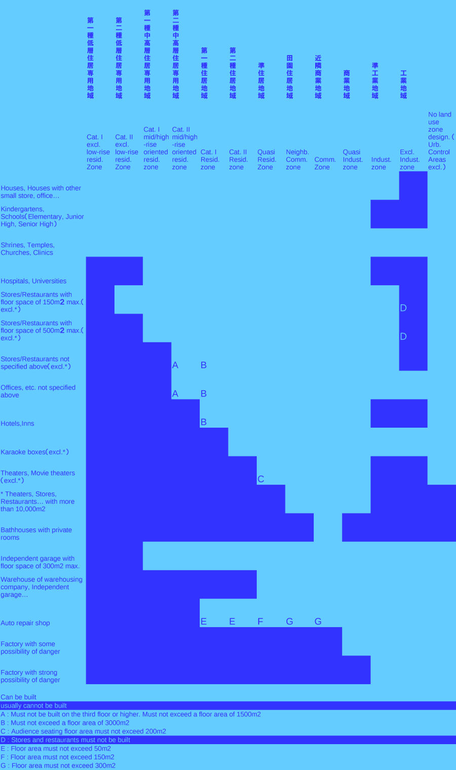
Land use in Japanese zoning system tend to be "inclusive" rather than "exclusive". Japanese zoning system do not impose one or two exclusive uses for every zone, except for the Exclusively industrial zone 工業地域 - kōgyō chiiki, where only factory buildings are permitted. These make sense, if you would like to keep the heavy industry separate from other uses. In this case zoning is used to separate sites that have high levels of pollution from residential or business areas. A typical "exclusive" zoning system is the North American, where each zone tends to separate the function ( eg. residential from commercial) and the building typology (eg. multi residential buildings from single-family houses). The consequence is that all the properties in a given area are worth about the same amount in value, what allows only those who can afford the area to live there often forcing out lower income families. This great rigidity also increase the need of competence from urban planners to have a decent city. If the urban planners doesn't plan for enough multi residential buildings zones, there may be shortages of these kind of housing, pushing prices up. If there is not enough commercial zones or schools, they might be built on the outskirts of the city, necessitating a car to get to them from residential areas. On the other hand in Japan zoning gives much more flexibility to cities by promoting multi use areas ( "inclusive" rather than "exclusive"). For example in Japan a small restaurant with floor space of 150 sqm max. can be built almost in every zone. In this system the Category I exclusively low-rise residential zone 第一種低層住居専用地域 - dai ichi shu teisō jūkyo sen'yō chiiki, is the most restrictive, and the Commercial zone 近隣商業地域 - kinrin shōgyō chiiki, is the one where almost any type of building can be built (except heavy industrial). This means that if a city would like to concede an amusement park in the same zone have to permit also offices, commercial building and residential building. Here, to see some examples, you can navigate through the city planning information of Kyoto: Kyoto city planning information
Districts
The municipality in Japan, especially the ones with particular local characteristics, can strengthen or relax the control over matters such as usage, density, building heights, setbacks, exterior colors, and much more by creating Districts.
District plans
District plans may override the zone restrictions, such as building coverage and floor area ratios.
Variations of District Plans include:
1 Redevelopment promotion district (relaxation of the maximum floor-area ratio when in conjunction with the improvement of public facilities).
2 Large-scale store development promotion district (Large-scale shopping complexs, theaters, etc. can be permitted when in conjuction with the improvement of public facillities).
3 Public facilities development promoting-type (phased application of the maximum floor-area ratio in response to the state of improvement of public local roads).
4 Floor-area ratio transfer-type(floor-area ratio is distributed within an area)
5 Efficient land utilization-type(increased floor-area ratio, if open space is provided)
6 Urban housing development promotion-type(up to 50% increase of floor-area ratio for residential use)
7 Building shapes coordinating-type(exemption of the restrictions on the floor-area ratio according to the width of the adjoining road in exchange for height restriction)
8 Disaster Prevention Block Improvement District Plan(promotion of road/park development and fire-resistant building structures for disaster prevention)
9 Roadside District Plan(promotion of noise prevention and high-rise buildings along trunk roads)
10 Rural District Plan(establishment of a good residential environment in harmony with requirements for farming)
Building Coverage Ratio (BCR) 建蔽率 Kenperitsu and the floor area ratio (FAR) 容積率 yousekiritsu
Each zone restricts the building size and density by prescribing the numbers used to calculate the buildable area 建蔽率 Kenperitsu and 容積率 yousekiritsu (Building Coverage Ratio - BCR and floor area ratio - FAR).
The purpose of the BCR 建蔽率 or 建ぺい率 Kenperitsu is to limit building density, preventing fires from spreading between adjacent buildings; ensuring light and air penetration; controlling urban character.
Kenperitsu (BCR)% = building coverage area / site area × 100
Japan has extensively adopted the floor area ratio in the zoning system since 1970. Some say that it has deteriorated the skylines and building lines in Japanese cities, others claim that it has protected the residential environments. The floor area ratio (FAR) – yousekiritsu 容積率 – sets the maximum possible floor area, totalled across all floors and expressed as a percentage of the site area. In other countries Floor Area ratio is sometimes called floor space ratio (FSR), floor space index (FSI), site ratio or plot ratio. The difference between FAR and FSI is that the first FAR a ratio, while the FSI is an index. For example 250% FAR is 2.5 FSI.
Yousekiritsu (FAR)% = total floor area / site area × 100
When constructing buildings across multiple zones with different prescribed ratios, in Japan, BRC and FAR should be calculated with a weighted average.
Setbacks
Setback refers to the area in a parcel of land where a building may not be constructed. The most common setback in Japan is defined by the minimum road width. Roads in Japan should be at least 4 meters wide (to allow emergency vehicles to use them). In reality, old roadways in Japan are often narrower. In these cases, the building must be setback from the center of the old roadway by at least 2 meters. The area of the setback is excluded from the calculation of the BCR and FAR.
Further setbacks can be introduced by districts for controlling urban density, preserve views on mountains or historical buildings etc.
Height Restrictions
Why one would do height limits? One can argue that you need to allow some sun to shine on the street or to allow some air to flow. Those are good arguments, but how to define those numbers? In many countries those numbers are just arbitrary limits. In Japan the height limit is a parametric calculation, defined by the plot size, and the road width. I'm not saying that this is the ideal solution, but make more sense, than an urban planner deciding how many stories a building should have.
Slant plane Restrictions in Japan is limiting building heights in proportion to the distance from the other side of the boundaries of the roads they face, or from the adjacent site boundaries. It ensures adequate space for light and ventilation between buildings or on roads.
There are three types of slant planes, each is calculated differently, corresponding to the different boundaries of the site: road boundaries, adjacent plot boundaries and north-facing boundaries.
So, for example, the farther the building is set back from the street, the higher it can be.
District plans may override these rules, where they want to build offices in skyscrapers for example.
Where to get informations
This guide is by no means complete, is just a quick overview of aspects of Japanese Building Standard Law. It is also a way l to show how things can be done differently.
links
wikipedia japanese administrative divisions
https://en.wikipedia.org/wiki/Administrative_divisions_of_Japan
wikipedia japanese zoning

This convention is for naming files prepared by IBA, with the aim to design a convention that remains simple enough to be practical for small companies and small projects. At the same time this convention is sufficiently flexible for larger and more complex projects.

This convention is for naming the folders prepared by IBA, with the aim to design a convention that remains simple enough to be practical for small architecture companies and small design projects. At the same time this convention is sufficiently flexible for larger and more complex projects.

A Masterplan should be both visionary and functional in order to help communities in developing urban spaces. Masterplanning should address complex issues that affect our towns and cities by providing design excellence and a multidisciplinary vision.

Why You Should Hire an Architect firm to design a building?
Architect can help you to make a building more useful and fascinating to the people who own and inhabit them, more integrated to their context and more commercially sustainable. The focus is to create total environments, connected interiors and exteriors, that are useful and exciting places in which to live.

Why You Should Hire an Architect to design the interiors of your house or office?
Architect can help you bring your spaces to life while making sure to satisfie considerations such as space planning and building codes. A trained eye and a creative mind with attention to the tiniest details, can find solutions that you might never have imagined.

A few years ago I was asked to write an introduction to a book on the beginning and the essence of the architectural project: Architecture is a visionary and magical game that requires a particular calling that approaches the religious, like the role of a priest. The process of architectural design is almost manic: rules are learned by everyday existence, watching life on the streets, people, nature, details, construction. The architect looks at the world around him to learn and understand from what has evolved in nature and been built by humans.
- You are here:
-
Home

-
HOME
-
Ivo Buda Website EN
- Blog